Summary
Part of the Bwlch - an amazing Flying Panorama encompassing all wind directions and one of the best flying sites in the UK. The site can be found on the A4061 at the end of the Ogmore Valley in South Wales, with The Ice Cream Slope making up the NW portion of the Panorama.Home to the South Wales Soaring Association for many years and also host of many F3F competitions.
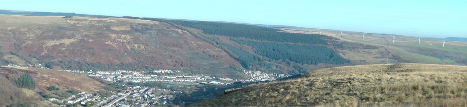
The Ice cream slope, so named as a result of the ice cream van parked almost year round in the layby, takes care of the NW direction of the Bwlch. Overlooking Treorchy the view, and flying are spectacular.
This slope works particularly well when the wind is absolutely bang on 90 degrees. It can certainly be flown in a NNW and even a WNW - but disruption from the VR98 slope opposite can cause odd disturbances on the left of the slope in a WNW - and frankly in a NNW - you are perhaps better off trying the VR98 itself.
Location
Situated on the A4061, known on maps as Bwlch-y-Clwdd Road, the Bwlch Site is situated a ten minutes drive from the village of NantyMoel when approaching from the ogmore valley (Bridgend) side and an equal distance from the village of Treorchy when approaching from the Northeast side.
The Ice Cream Slope on Google Maps
Parking is the same as for Mickeys; On the A4061 in the area that gives the Bwlch Ice Cream Slope its name, a layby above Treorchy that is usually occupied by an ice cream van, tourist's with cameras, and more than a few sheep.
Parking for a few cars is also available right next to the forestry access road that winds its way up towards Mickey's. Don't park in front of the barrier as access is needed at all times for the forestry commission and emergency services.
Details
| Attribute | Information |
|---|---|
| Height(m) | 900 feet |
| Directions | NW, WNW, NNW |
| SatnNav N/E | 51.639341, -3.533174 |
| SatnNav Road | Bwlch-Y-Clawdd Road, UK |
| Rotor | Rarely any at all |
| Landing | Very good and safe landing immediately behind the slope. Don't go too far to the back and right - there is a quarry and you'll want to be well short of that. |
| Accessibility | Relatively easy walk along the path from the car only 10-15 or so minutes to where the ground levels off flat. Boots are good shpoes advisable in the winter months or after serious rain as the path can channel a bit of water sometimes. |
| Paragliding | Unlike Mickeys slope - it would be a rare find to see a paraglider on the ice cream slope - but as they can be in the area - if thermalling on a light breeze day - best keep your eyes open just in case. |
| Wildlife | Sheep Birds of prey - Buzzards, Red Kites, Peregrine Falcons |
| Other | Another staggering site - but as all of the Bwlch - can be prone to "Welsh Weather" Clag on damp low cloud days. Have a gander at the webcam to check out the clag situation and other weather information if in doubt NantyMoel Weather Station and webcam |
Map of Access / Path - Courtesy of Google Earth

Images of the Ice Cream Slope at the Bwlch
On the edge of the Ice Cream Slope facing NW

Looking towards the huge Crest opposite the Ice Cream slope

On slope edge looking North towards Treorchy

F3F Images

F3F Welsh Open 2010 slideshow (Mike Shellim)
Videos of the Ice Cream Slope at the Bwlch
Panorama scanning across the Ice Cream Slope towards VR98, Wrecker & Crest
F3F on the Ice Cream Feb 2012 (rumbey1)
Others Videos (Vimeo)
No comments:
Post a Comment